Cafe nearby McDonald's
Coronavirus disease (COVID-19) Situation
confirmed cases
4946090
deaths
59034
Canada
Cafe nearby McDonald's
McDonald's
77, Bank Street, K1P 5N2, Ottawa, Ottawa Division, CA Kanada
contacts phone
:
+1 613-237-5854
website:
www.mcdonalds.com
Latitude:
45.4208507
, Longitude:
-75.70091
larger map & directions
read more
nearest Cafe
20 m
Roast 'N Brew Coffee House
83 Bank Street, Ottawa
Cafe
read more
47 m
Tim Hortons
200 Sparks Street, Ottawa
Cafe
read more
232 m
Tim Hortons
171 Slater Street, Ottawa
Cafe
read more
234 m
Marcello's Market and Deli
280 Slater Street, Ottawa
Cafe
read more
277 m
Tim Hortons
269 Laurier Avenue West, Ottawa
Cafe
read more
337 m
Bridgehead
344 Slater Street, Ottawa
Cafe
read more
385 m
Cafe Deluxe
77 Metcalfe Street, Ottawa
Cafe
read more
433 m
City's Sky Coffee
120 Metcalfe Street, Ottawa
Cafe
read more
519 m
Treats
66 Slater Street, Ottawa
Cafe
read more
587 m
Starbucks
100 Elgin Street, Ottawa
Cafe
read more
638 m
Bridgehead
160 Elgin St, Ottawa, ON K2P 2C4 Elgin Street, Ottawa
Cafe
read more
842 m
Tim Hortons
525 Somerset Street West, Ottawa
Cafe
read more
890 m
Ebar
500-50 Rideau Street, Ottawa
Cafe
read more
892 m
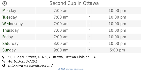
Second Cup
50 Rideau Street, Ottawa
Cafe
read more
932 m
The Ministry of Coffee
279 Elgin Street, Ottawa
Cafe
read more
981 m
Quelque Chose Macarons & Coffee
70 George Street, Ottawa
Cafe
read more
1.006 km
Maple Valley Tea World
55 Byward Market Square #14, Ottawa
Cafe
read more
1.029 km
CACAO 70 Eatery
53 William Street #51, Ottawa
Cafe
read more
1.058 km
Kava
410 Bank Street, Ottawa
Cafe
read more
1.068 km
Starbucks
62 York Street, Ottawa
Cafe
read more
1.079 km
MOW
670 Albert Street, Ottawa
Cafe
read more
1.091 km
Pure Kitchen
340 Elgin Street, Ottawa
Cafe
read more
1.185 km
HeadQuarters
113 - 115 Clarence Street, Ottawa
Cafe
read more
1.189 km
Timothy's
Place Du Centre, 200 Promenade du Portage, Gatineau
Cafe
read more
1.212 km
Café Vasanti (200 Promenade du Portage)
200 Promenade Du Portage, Gatineau
Cafe
read more
📑
all categories
Accounting
Administrative area level 1
Administrative area level 2
Airport
Amusement park
Aquarium
Art gallery
Atm
Bakery
Bank
Bar
Beauty salon
Bicycle store
Book store
Bowling alley
Bus station
Cafe
Campground
Car dealer
Car rental
Car repair
Car wash
Casino
Cemetery
Church
City hall
Clothing store
Colloquial area
Convenience store
Courthouse
Dentist
Department store
Doctor
Electrician
Electronics store
Embassy
Finance
Fire station
Florist
Food
Funeral home
Furniture store
Gas station
General contractor
Grocery or supermarket
Gym
Hair care
Hardware store
Health
Hindu Temple
Home goods store
Hospital
Insurance agency
Jewelry store
Laundry
Lawyer
Library
Light rail station
Liquor store
Local government office
Locality
Locksmith
Lodging
Meal delivery
Meal takeaway
Mosque
Movie rental
Movie theater
Moving company
Museum
Natural feature
Neighborhood
Night club
Painter
Park
Parking
Pet store
Pharmacy
Physiotherapist
Place of worship
Plumber
Point of interest
Police
Political
Post office
Premise
Real estate agency
Restaurant
Roofing contractor
Route
Rv park, camping
School
Shoe store
Shopping mall
Spa
Stadium
Storage
Store
Subpremise
Subway station
Supermarket
Synagogue
Taxi stand
Train station
Transit station
Travel agency
University
Veterinary care
Zoo
administrative area level 3
sublocality level 1
↑