Cafe nearby Treats
Canada
Cafe nearby Treats
Treats
66, Slater Street, K1P 5H1, Ottawa, Ottawa Division, CA Canada
contacts phone
:
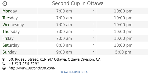
+1 613-237-8052
website:
www.treats.com
Latitude:
45.4213915
, Longitude:
-75.69431
larger map & directions
read more
nearest Cafe
80 m
Starbucks
100 Elgin Street, Ottawa
Cafe
read more
141 m
Cafe Deluxe
77 Metcalfe Street, Ottawa
Cafe
read more
148 m
City's Sky Coffee
120 Metcalfe Street, Ottawa
Cafe
read more
214 m
Bridgehead
160 Elgin St, Ottawa, ON K2P 2C4 Elgin Street, Ottawa
Cafe
read more
318 m
Tim Hortons
171 Slater Street, Ottawa
Cafe
read more
415 m
Tim Hortons
269 Laurier Avenue West, Ottawa
Cafe
read more
450 m
Second Cup
50 Rideau Street, Ottawa
Cafe
read more
476 m
Ebar
500-50 Rideau Street, Ottawa
Cafe
read more
505 m
Tim Hortons
200 Sparks Street, Ottawa
Cafe
read more
510 m
Roast 'N Brew Coffee House
83 Bank Street, Ottawa
Cafe
read more
547 m
The Ministry of Coffee
279 Elgin Street, Ottawa
Cafe
read more
567 m
Marcello's Market and Deli
280 Slater Street, Ottawa
Cafe
read more
648 m
Quelque Chose Macarons & Coffee
70 George Street, Ottawa
Cafe
read more
673 m
Jackson Café
50 Mackenzie King Bridge, Ottawa
Cafe
read more
710 m
Maple Valley Tea World
55 Byward Market Square #14, Ottawa
Cafe
read more
721 m
CACAO 70 Eatery
53 William Street #51, Ottawa
Cafe
read more
736 m
Bridgehead
344 Slater Street, Ottawa
Cafe
read more
737 m
Café Alternatif
75 Laurier Avenue East, Ottawa
Cafe
read more
744 m
Pure Kitchen
340 Elgin Street, Ottawa
Cafe
read more
775 m
Starbucks
62 York Street, Ottawa
Cafe
read more
924 m
HeadQuarters
113 - 115 Clarence Street, Ottawa
Cafe
read more
943 m
Cafe Ecolo
145 Jean-Jacques-Lussier Private, Ottawa
Cafe
read more
944 m
Not Your Father's Barber
91 Murray Street, Ottawa
Cafe
read more
979 m
Kava
410 Bank Street, Ottawa
Cafe
read more
1.072 km
Tim Hortons
525 Somerset Street West, Ottawa
Cafe
read more
📑
all categories
Accounting
Administrative area level 1
Administrative area level 2
Airport
Amusement park
Aquarium
Art gallery
Atm
Bakery
Bank
Bar
Beauty salon
Bicycle store
Book store
Bowling alley
Bus station
Cafe
Campground
Car dealer
Car rental
Car repair
Car wash
Casino
Cemetery
Church
City hall
Clothing store
Colloquial area
Convenience store
Courthouse
Dentist
Department store
Doctor
Electrician
Electronics store
Embassy
Finance
Fire station
Florist
Food
Funeral home
Furniture store
Gas station
General contractor
Grocery or supermarket
Gym
Hair care
Hardware store
Health
Hindu Temple
Home goods store
Hospital
Insurance agency
Jewelry store
Laundry
Lawyer
Library
Light rail station
Liquor store
Local government office
Locality
Locksmith
Lodging
Meal delivery
Meal takeaway
Mosque
Movie rental
Movie theater
Moving company
Museum
Natural feature
Neighborhood
Night club
Painter
Park
Parking
Pet store
Pharmacy
Physiotherapist
Place of worship
Plumber
Point of interest
Police
Political
Post office
Premise
Real estate agency
Restaurant
Roofing contractor
Route
Rv park, camping
School
Shoe store
Shopping mall
Spa
Stadium
Storage
Store
Subpremise
Subway station
Supermarket
Synagogue
Taxi stand
Train station
Transit station
Travel agency
University
Veterinary care
Zoo
administrative area level 3
sublocality level 1
↑