Cafe nearby Tim Hortons
Canada
Cafe nearby Tim Hortons
Tim Hortons
120 Montreal Road, Vanier Canadá
contacts phone
:
+1
Latitude:
45.4340638
, Longitude:
-75.6660457
read more
nearest Cafe
66 m
Tim Hortons
115 Montreal Road, Vanier
Cafe
read more
136 m
Cafe Caco
77 Montreal Road, Vanier
Cafe
read more
565 m
Quelque Chose Pâtisserie
274 Montreal Road, Vanier
Cafe
read more
994 m
Zourinos Cafe
320 McArthur Avenue, Vanier
Cafe
read more
1.004 km
Tea Tyme
81 Beechwood Avenue, Ottawa
Cafe
read more
1.008 km
Red Door Provisions
117 Beechwood Avenue, Ottawa
Cafe
read more
1.012 km
Bridgehead
131 Beechwood Avenue, Ottawa
Cafe
read more
1.032 km
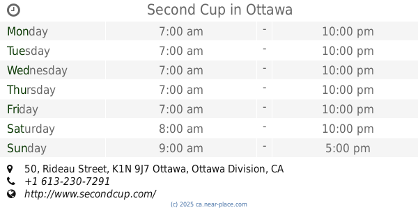
Second Cup
1 Springfield Road, Ottawa
Cafe
read more
1.044 km
Fraser Cafe
7 Springfield Road, Ottawa
Cafe
read more
1.051 km
Maison Baguettes Etc
381 Montreal Road, Vanier
Cafe
read more
1.094 km
Starbucks
409 MacKay Street, Ottawa
Cafe
read more
1.153 km
The Guild Room
10 Blackburn Avenue, Ottawa
Cafe
read more
1.153 km
The Guild Room
Blackburn Avenue, Ottawa
Cafe
read more
1.235 km
Black Starliner Studio
430 Rideau Street, Ottawa
Cafe
read more
1.748 km
Second Cup
153 Laurier Avenue East, Ottawa
Cafe
read more
1.815 km
Tim Hortons
360 Saint Patrick Street Unit 2, Ottawa
Cafe
read more
1.843 km
Cafe Ecolo
145 Jean-Jacques-Lussier Private, Ottawa
Cafe
read more
1.888 km
Second Cup
85 University Private #110, Ottawa
Cafe
read more
1.907 km
Tim Hortons
800 King Edward, 1st Floor, Ottawa
Cafe
read more
1.912 km
Café Alternatif
75 Laurier Avenue East, Ottawa
Cafe
read more
1.95 km
Starbucks
380 Coventry Road, Ottawa
Cafe
read more
1.959 km
Jackson Café
50 Mackenzie King Bridge, Ottawa
Cafe
read more
2.2 km
Second Cup
50 Rideau Street, Ottawa
Cafe
read more
2.205 km
Ebar
500-50 Rideau Street, Ottawa
Cafe
read more
2.615 km
The Ministry of Coffee
279 Elgin Street, Ottawa
Cafe
read more
📑
all categories
Accounting
Administrative area level 1
Administrative area level 2
Airport
Amusement park
Aquarium
Art gallery
Atm
Bakery
Bank
Bar
Beauty salon
Bicycle store
Book store
Bowling alley
Bus station
Cafe
Campground
Car dealer
Car rental
Car repair
Car wash
Casino
Cemetery
Church
City hall
Clothing store
Colloquial area
Convenience store
Courthouse
Dentist
Department store
Doctor
Electrician
Electronics store
Embassy
Finance
Fire station
Florist
Food
Funeral home
Furniture store
Gas station
General contractor
Grocery or supermarket
Gym
Hair care
Hardware store
Health
Hindu Temple
Home goods store
Hospital
Insurance agency
Jewelry store
Laundry
Lawyer
Library
Light rail station
Liquor store
Local government office
Locality
Locksmith
Lodging
Meal delivery
Meal takeaway
Mosque
Movie rental
Movie theater
Moving company
Museum
Natural feature
Neighborhood
Night club
Painter
Park
Parking
Pet store
Pharmacy
Physiotherapist
Place of worship
Plumber
Point of interest
Police
Political
Post office
Premise
Real estate agency
Restaurant
Roofing contractor
Route
Rv park, camping
School
Shoe store
Shopping mall
Spa
Stadium
Storage
Store
Subpremise
Subway station
Supermarket
Synagogue
Taxi stand
Train station
Transit station
Travel agency
University
Veterinary care
Zoo
administrative area level 3
sublocality level 1
↑