Park nearby Plouffe Park
Coronavirus disease (COVID-19) Situation
confirmed cases
4946090
deaths
59034
Canada
Park nearby Plouffe Park
Plouffe Park
130 Preston Street, Ottawa Canada
contacts phone
:
+1
Latitude:
45.407155
, Longitude:
-75.7143221
read more
nearest Park
320 m
Park Chaudiere
68 Elm Street, Ottawa
Park
read more
344 m
Trillium Pathway
204 Champagne - O-Train Corridor Multi-Use Pathway, Ottawa
Park
read more
444 m
Primrose Park
179 Primrose Avenue, Ottawa
Park
read more
496 m
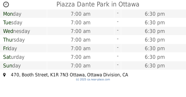
Piazza Dante Park
470 Booth Street, Ottawa
Park
read more
519 m
Sweet Willow Community Garden
31 Rochester Street, Ottawa
Park
read more
571 m
Dalhousie Community Centre Park
Ottawa
Park
read more
626 m
Somerset Square Park
2 Spadina Avenue, Ottawa
Park
read more
735 m
Bayview Friendship Park
128 Bayview Road, Ottawa
Park
read more
805 m
Armstrong Park
69 Armstrong Street, Ottawa
Park
read more
846 m
Hintonburg Park
Ottawa
Park
read more
861 m
Ev Tremblay Park
108 Beech Street, Ottawa
Park
read more
894 m
McNabb Park
Ottawa
Park
read more
919 m
McCann Park
80 Norman Street, Ottawa
Park
read more
988 m
LeBreton Flats Park
Ottawa
Park
read more
1.048 km
Dalhousie Park
Ottawa
Park
read more
1.063 km
Nanny Goat Hill Community Garden
1 Laurier Avenue West, Ottawa
Park
read more
1.064 km
Fairmont Park
Ottawa
Park
read more
1.103 km
Tech Wall Dog Park
551-575 Laurier Avenue West, Ottawa
Park
read more
1.22 km
Glebe Memorial Park
Ottawa
Park
read more
1.236 km
Lisgar Parkette
Ottawa
Park
read more
1.324 km
The Centretown Community Garden Project
Lisgar Street, Ottawa
Park
read more
1.73 km
Dow's Lake Peninsula
Ottawa
Park
read more
1.769 km
Stationnement
235 Queen Street, Ottawa
Park
read more
1.987 km
parking
ave w 5z9, 220 Laurier Avenue West, Ottawa
Park
read more
2.026 km
Montcalm-Taché Park
28 Boulevard Alexandre-Taché, Gatineau
Park
read more
📑
all categories
Accounting
Administrative area level 1
Administrative area level 2
Airport
Amusement park
Aquarium
Art gallery
Atm
Bakery
Bank
Bar
Beauty salon
Bicycle store
Book store
Bowling alley
Bus station
Cafe
Campground
Car dealer
Car rental
Car repair
Car wash
Casino
Cemetery
Church
City hall
Clothing store
Colloquial area
Convenience store
Courthouse
Dentist
Department store
Doctor
Electrician
Electronics store
Embassy
Finance
Fire station
Florist
Food
Funeral home
Furniture store
Gas station
General contractor
Grocery or supermarket
Gym
Hair care
Hardware store
Health
Hindu Temple
Home goods store
Hospital
Insurance agency
Jewelry store
Laundry
Lawyer
Library
Light rail station
Liquor store
Local government office
Locality
Locksmith
Lodging
Meal delivery
Meal takeaway
Mosque
Movie rental
Movie theater
Moving company
Museum
Natural feature
Neighborhood
Night club
Painter
Park
Parking
Pet store
Pharmacy
Physiotherapist
Place of worship
Plumber
Point of interest
Police
Political
Post office
Premise
Real estate agency
Restaurant
Roofing contractor
Route
Rv park, camping
School
Shoe store
Shopping mall
Spa
Stadium
Storage
Store
Subpremise
Subway station
Supermarket
Synagogue
Taxi stand
Train station
Transit station
Travel agency
University
Veterinary care
Zoo
administrative area level 3
sublocality level 1
↑