Cafe nearby Styles Liquid Roast Coffee
Coronavirus disease (COVID-19) Situation
confirmed cases
4946090
deaths
59034
Canada
Cafe nearby Styles Liquid Roast Coffee
Styles Liquid Roast Coffee
151 Roslyn Road #6, Winnipeg Kanada
contacts phone
:
+1
Latitude:
49.880007
, Longitude:
-97.14888
read more
nearest Cafe
90 m
Tim Hortons
499 River Avenue, Winnipeg
Cafe
read more
155 m
Starbucks
481 River Avenue #1, Winnipeg
Cafe
read more
203 m
Little Sister Coffee Maker
A-470 River Avenue, Winnipeg
Cafe
read more
425 m
Tim Hortons
80 Osborne Street North, Winnipeg
Cafe
read more
671 m
Tea Story Cafe
224 Osborne Street, Winnipeg
Cafe
read more
788 m
Thom Bargen Coffee and Tea
64 Sherbrook Street, Winnipeg
Cafe
read more
797 m
Woodsworth Cafe
405 Broadway, Winnipeg
Cafe
read more
829 m
Stella's on Sherbrook
116 Sherbrook Street, Winnipeg
Cafe
read more
839 m
Sips & Nibbles Cafe
103-5 Donald st., Winnipeg
Cafe
read more
869 m
Fools & Horses
379 Broadway, Winnipeg
Cafe
read more
895 m
Tim Hortons
363 Broadway, Winnipeg
Cafe
read more
936 m
Café 22
336 Broadway, Winnipeg
Cafe
read more
979 m
G G Gelati
705 Corydon Avenue, Winnipeg
Cafe
read more
994 m
Cafe La Scala
725 Corydon Avenue, Winnipeg
Cafe
read more
1.019 km
The Fyxx Espresso Bar
310 Broadway, Winnipeg
Cafe
read more
1.028 km
Ramallah Cafe After Hours
325 Pembina Highway, Winnipeg
Cafe
read more
1.036 km
Starbucks
745 Corydon Avenue, Winnipeg
Cafe
read more
1.082 km
Starbucks
305 Broadway, Winnipeg
Cafe
read more
1.109 km
Tim Hortons
255 Maryland St, Winnipeg
Cafe
read more
1.359 km
Luna Cafe
393 Portage Avenue, Winnipeg
Cafe
read more
1.365 km
HUMAN BEAN COFFEE & TEA
1-333 Saint Mary Avenue, Winnipeg
Cafe
read more
1.494 km
Tim Hortons
19 Marion Street, Winnipeg
Cafe
read more
1.87 km
McDonald's
630 Pembina Highway, Winnipeg
Cafe
read more
2.01 km
Winnipeg Free Press News Café
237 McDermot Avenue, Winnipeg
Cafe
read more
2.134 km
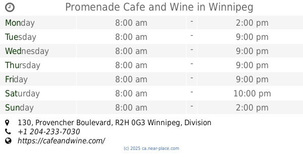
Promenade Cafe and Wine
130 Provencher Boulevard, Winnipeg
Cafe
read more
📑
all categories
Accounting
Administrative area level 1
Administrative area level 2
Airport
Amusement park
Aquarium
Art gallery
Atm
Bakery
Bank
Bar
Beauty salon
Bicycle store
Book store
Bowling alley
Bus station
Cafe
Campground
Car dealer
Car rental
Car repair
Car wash
Casino
Cemetery
Church
City hall
Clothing store
Colloquial area
Convenience store
Courthouse
Dentist
Department store
Doctor
Electrician
Electronics store
Embassy
Finance
Fire station
Florist
Food
Funeral home
Furniture store
Gas station
General contractor
Grocery or supermarket
Gym
Hair care
Hardware store
Health
Hindu Temple
Home goods store
Hospital
Insurance agency
Jewelry store
Laundry
Lawyer
Library
Light rail station
Liquor store
Local government office
Locality
Locksmith
Lodging
Meal delivery
Meal takeaway
Mosque
Movie rental
Movie theater
Moving company
Museum
Natural feature
Neighborhood
Night club
Painter
Park
Parking
Pet store
Pharmacy
Physiotherapist
Place of worship
Plumber
Point of interest
Police
Political
Post office
Premise
Real estate agency
Restaurant
Roofing contractor
Route
Rv park, camping
School
Shoe store
Shopping mall
Spa
Stadium
Storage
Store
Subpremise
Subway station
Supermarket
Synagogue
Taxi stand
Train station
Transit station
Travel agency
University
Veterinary care
Zoo
administrative area level 3
sublocality level 1
↑