Cafe nearby Espresso Junction Inc
Coronavirus disease (COVID-19) Situation
confirmed cases
4946090
deaths
59034
Canada
Cafe nearby Espresso Junction Inc
Espresso Junction Inc
25 Forks Market Road, Winnipeg Kanada
contacts phone
:
+1
Latitude:
49.8871975
, Longitude:
-97.1299364
read more
nearest Cafe
129 m
Fools & Horses
1 Forks Market Road, Winnipeg
Cafe
read more
480 m
Cafe Oasis
409 Tache Avenue, Winnipeg
Cafe
read more
580 m
Tim Hortons
19 Marion Street, Winnipeg
Cafe
read more
582 m
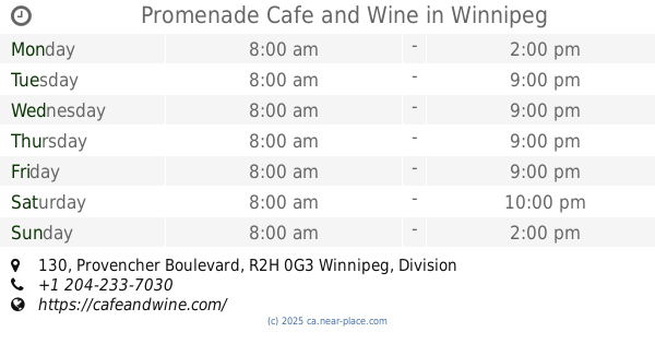
Promenade Cafe and Wine
130 Provencher Boulevard, Winnipeg
Cafe
read more
661 m
McDonald's
77 Goulet Street, Winnipeg
Cafe
read more
708 m
Dwarf no Cachette Café & Gift
157 Provencher Boulevard, Winnipeg
Cafe
read more
733 m
Starbucks
305 Broadway, Winnipeg
Cafe
read more
751 m
The Fyxx Espresso Bar
310 Broadway, Winnipeg
Cafe
read more
801 m
Tim Hortons
1 Portage Avenue East, Winnipeg
Cafe
read more
831 m
Grey Owl Coffee (and Pub)
Winnipeg
Cafe
read more
840 m
Café 22
336 Broadway, Winnipeg
Cafe
read more
848 m
Café Postal
202 Provencher Boulevard, Winnipeg
Cafe
read more
897 m
Tim Hortons
240 Graham Avenue, Winnipeg
Cafe
read more
907 m
Sips & Nibbles Cafe
103-5 Donald st., Winnipeg
Cafe
read more
955 m
Ridgeway Coffee Equipment Svc
PO Box 5 Stn Main, Winnipeg
Cafe
read more
970 m
Starbucks
266 Graham Avenue, Winnipeg
Cafe
read more
1.008 km
Tim Hortons
333 Saint Mary Avenue, Winnipeg
Cafe
read more
1.015 km
McDonald's
Unit 102-H, 333 Saint Mary Avenue, Winnipeg
Cafe
read more
1.022 km
Cookies By George
360 Main Street, Winnipeg
Cafe
read more
1.071 km
HUMAN BEAN COFFEE & TEA
1-333 Saint Mary Avenue, Winnipeg
Cafe
read more
1.085 km
Starbucks
2 Lombard Place, Winnipeg
Cafe
read more
1.115 km
Tim Hortons
1 Lombard Avenue, Winnipeg
Cafe
read more
1.132 km
Baires Gelato & Cafe
101-250 Marion Street, Winnipeg
Cafe
read more
1.153 km
Starbucks
288 Portage Avenue, Winnipeg
Cafe
read more
1.162 km
Starbucks
201 Portage Ave, 100, Winnipeg
Cafe
read more
📑
all categories
Accounting
Administrative area level 1
Administrative area level 2
Airport
Amusement park
Aquarium
Art gallery
Atm
Bakery
Bank
Bar
Beauty salon
Bicycle store
Book store
Bowling alley
Bus station
Cafe
Campground
Car dealer
Car rental
Car repair
Car wash
Casino
Cemetery
Church
City hall
Clothing store
Colloquial area
Convenience store
Courthouse
Dentist
Department store
Doctor
Electrician
Electronics store
Embassy
Finance
Fire station
Florist
Food
Funeral home
Furniture store
Gas station
General contractor
Grocery or supermarket
Gym
Hair care
Hardware store
Health
Hindu Temple
Home goods store
Hospital
Insurance agency
Jewelry store
Laundry
Lawyer
Library
Light rail station
Liquor store
Local government office
Locality
Locksmith
Lodging
Meal delivery
Meal takeaway
Mosque
Movie rental
Movie theater
Moving company
Museum
Natural feature
Neighborhood
Night club
Painter
Park
Parking
Pet store
Pharmacy
Physiotherapist
Place of worship
Plumber
Point of interest
Police
Political
Post office
Premise
Real estate agency
Restaurant
Roofing contractor
Route
Rv park, camping
School
Shoe store
Shopping mall
Spa
Stadium
Storage
Store
Subpremise
Subway station
Supermarket
Synagogue
Taxi stand
Train station
Transit station
Travel agency
University
Veterinary care
Zoo
administrative area level 3
sublocality level 1
↑