Point of interest nearby Prince George Comm Radio Society
Canada
Point of interest nearby Prince George Comm Radio Society
Prince George Comm Radio Society
2880 15th Avenue, Prince George Kanada
contacts phone
:
+1
Latitude:
53.910406
, Longitude:
-122.77668
read more
nearest Point of interest
316 m
Navion Medical Imaging, Prince
2780 Ewert Crescent, Prince George
Point of interest
read more
548 m
Ducjmartin Installations Ltd
1593 Lyon Street South, Prince George
Point of interest
read more
790 m
Carrie Jane Gray Field
2210 Massey Drive, Prince George
Point of interest
read more
809 m
Compuworks Services & Training
1588 Ogilvie Street South, Prince George
Point of interest
read more
833 m
University Hospital of Northern British Columbia: Emergency Room
1475 Edmonton Street, Prince George
Point of interest
read more
843 m
Land Of Laughter
887 Carney St, Prince George
Point of interest
read more
897 m
Carly Tayler
2155 10th Avenue, Prince George
Point of interest
read more
910 m
Parallel 55
1990 Ogilvie Street South, Prince George
Point of interest
read more
947 m
Iris House
1111 Lethbridge Street, Prince George
Point of interest
read more
954 m
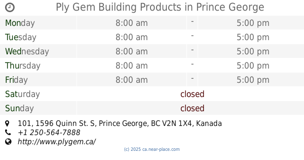
Ply Gem Building Products
101, 1596 Quinn St. S, Prince George
Point of interest
read more
976 m
Yellowhead Road & Bridge Ltd
1750 Quinn Street South, Prince George
Point of interest
read more
976 m
Geoterra Integrated Resource
101-1301 Kelliher Road, Prince George
Point of interest
read more
987 m
Aboriginal Housing Society Prince George
1919 17th Avenue, Prince George
Point of interest
read more
1.009 km
Spruce Capital Senior's Recreation Centre
3701 Rainbow Drive, Prince George
Point of interest
read more
1.213 km
Vanderhoof Specialty Wood
2121 6 Avenue, Prince George
Point of interest
read more
📑
all categories
Accounting
Administrative area level 1
Administrative area level 2
Airport
Amusement park
Aquarium
Art gallery
Atm
Bakery
Bank
Bar
Beauty salon
Bicycle store
Book store
Bowling alley
Bus station
Cafe
Campground
Car dealer
Car rental
Car repair
Car wash
Casino
Cemetery
Church
City hall
Clothing store
Colloquial area
Convenience store
Courthouse
Dentist
Department store
Doctor
Electrician
Electronics store
Embassy
Finance
Fire station
Florist
Food
Funeral home
Furniture store
Gas station
General contractor
Grocery or supermarket
Gym
Hair care
Hardware store
Health
Hindu Temple
Home goods store
Hospital
Insurance agency
Jewelry store
Laundry
Lawyer
Library
Light rail station
Liquor store
Local government office
Locality
Locksmith
Lodging
Meal delivery
Meal takeaway
Mosque
Movie rental
Movie theater
Moving company
Museum
Natural feature
Neighborhood
Night club
Painter
Park
Parking
Pet store
Pharmacy
Physiotherapist
Place of worship
Plumber
Point of interest
Police
Political
Post office
Premise
Real estate agency
Restaurant
Roofing contractor
Route
Rv park, camping
School
Shoe store
Shopping mall
Spa
Stadium
Storage
Store
Subpremise
Subway station
Supermarket
Synagogue
Taxi stand
Train station
Transit station
Travel agency
University
Veterinary care
Zoo
administrative area level 3
sublocality level 1
↑